Snow cover
Historical observational data shows that air temperatures in Canada have increased about twice as fast as the global average.
Quebec, located in the subarctic zone, is also experiencing significant warming. Over the last forty years, the province has warmed by 1 to 3 degrees, depending on the region, and much more markedly in winter.
This warming has an influence on:
The late appearance and early melting of the snow cover, meaning that its presence is shortened during the winter
The intensity of snowmelt periods
Winter precipitation in the form of rain or snow, which changes the existing snow cover
Snow cover variations in the Arctic and in North America
In the Arctic, recent observational data from the Intergovernmental Panel on Climate Change (IPCC) indicates that there was a delay of 1 to 3 months in the establishment of the snow cover in 2019.
Between 1967 and 2018, the extent of the terrestrial snow cover in this region in the month of June declined by about 13.4% per decade, with a total loss of about 2.5 million square kilometres.
In North America in 2023, high spring temperatures in the Northwest Territories and Nunavut resulted in the smallest area of snow cover recorded in 57 years of observations.
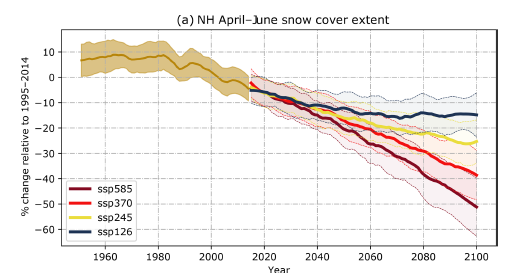
In the Northern Hemisphere, a recent study (Figure 1) found that:
Between 1981 and 2018, the extent of the snow cover has decreased in spring and autumn.
This downward trend will continue until 2100, with variations in magnitude depending on the greenhouse gas emissions scenario used.

Figure 1: Time series of the northern hemisphere spring (April to June) snow cover extent. Reference: from Figure 8 in Mudryk et al. (2020).
Snow cover variation in Canada and Quebec
Over most of Canada, observational data indicates that there has been a reduction in snow accumulation since 1981, representing a 5 to 10 percent decrease in snow cover per decade.
In Quebec, we are seeing a generalized delay in the first snow in the fall and earlier spring snow melt in the south. The snow cover lasts for less time and contains less water in the south of the province, but it has been lasting longer and contains more water in the north and centre of Quebec.
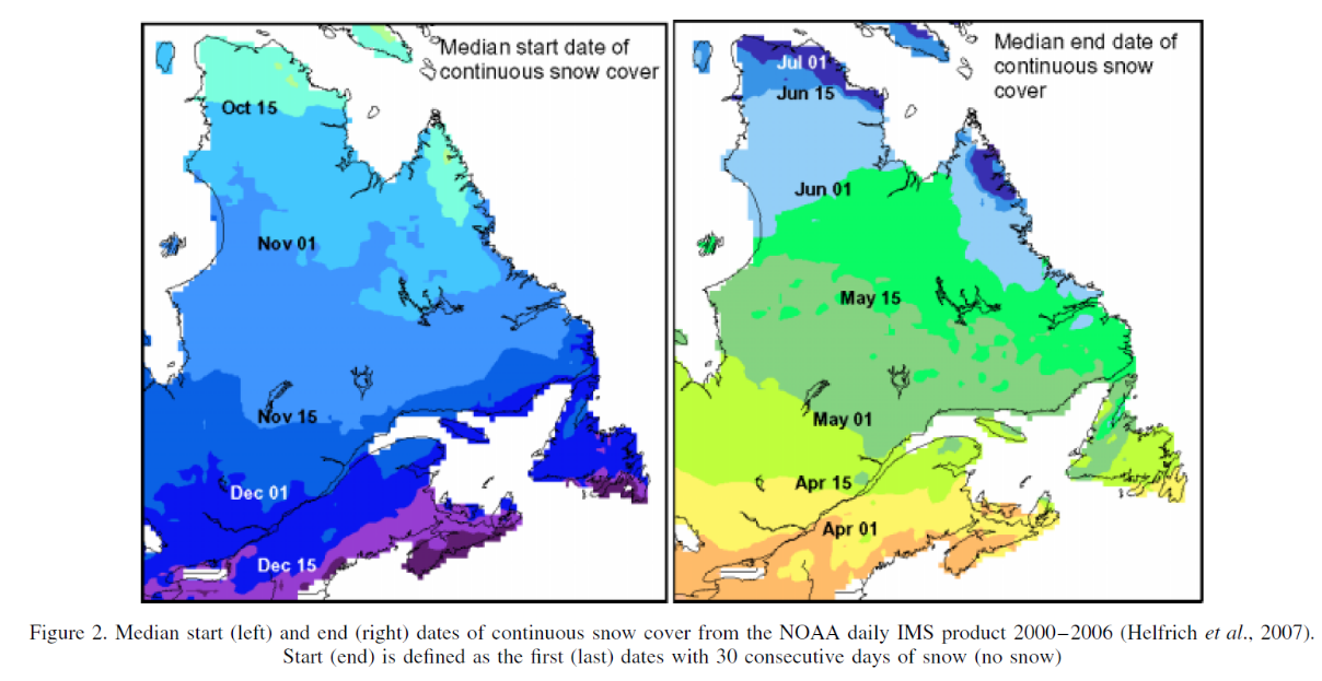
This variation in distribution between north and south is illustrated in the maps below. Between 2000 and 2006, the snow cover lasted on average 3.5 months in the south, from December 15 to April 1, and 8.5 months in the north, from October 15 to July 1.

Figure 2: Start (left map) and end (right map) of continuous snow cover. The snow cover start date and end date are chosen once there has been snow on the ground for 30 consecutive days. Reference: from Figure 2 in Brown (2010).
Observational data also shows that the maximum snow accumulation is lower in the northwest of the province (less than 100 mm of accumulation) than in the east (over 200 mm of accumulation).
The greatest accumulation is found at high altitudes.
Last update of the page : February 2026.