Coastal erosion and submergence
Quebec’s coastal communities are already confronting coastal erosion and submergence: a 2013 study found that 50% of coasts east of Québec City were at risk of coastal erosion, while 43% were potentially at risk of submergence.
In the administrative regions that are most severely affected—Bas-Saint-Laurent, Côte-Nord, Gaspésie, Îles-de-la-Madeleine, Capitale-Nationale and Chaudière-Appalaches—studies have recorded an average retreat rate of 0.37 m/year between 2000 and 2023.
However, the retreat rate can vary from one coast to another due to their composition. Erosion rates, for example, are higher in Chaudière-Appalaches, where coasts are composed of unconsolidated deposits, than in the Gaspé Peninsula, where rocky coastlines are more prevalent.
Coastal erosion and submergence can also occur suddenly. In some cases, coastal retreat of up to several metres can be observed during a single event.
Following post-tropical storm Fiona in September 2022, a retreat of almost 18 metres was recorded at a beach in Plaisance Bay, in the Magdalen Islands. A storm tide of at least 1.22 metres accompanied by waves 6 to 8 metres tall caused coastal submergence in several places during a storm surge.
Definition | Storm tide
A storm tide refers to the height of water when it rises above the expected tide level during a storm surge.
The influence of anthropogenic factors on coastal hazards
Although coastal retreat and flooding have been observed for several years, it is difficult to determine to what extent coastal erosion and submergence can be attributed solely to climate change, since other factors such as human activities have an influence on them.
Coastal squeeze
The presence of infrastructure such as roads, buildings, walls and riprap near the coast creates rigid barriers that restrict the natural dynamics of coastal ecosystems. Coastal squeeze refers to a phenomenon whereby a coastal ecosystem is trapped between rising water levels, which cause erosion of the shoreline, and a natural or artificial obstacle.
For example, the presence of rigid protective structures near coastal ecosystems blocks the movement of sediments inland and results in a deficit of sediments. Due to coastal squeeze, beaches and marshes are degrading and gradually disappearing.

By 2060, it is estimated that 25% of beach and marsh area could disappear if no measures are taken to limit the impacts of coastal squeeze. These natural environments are important, as they provide natural protection against coastal hazards by mitigating the risks of erosion and submergence.
Flanking erosion
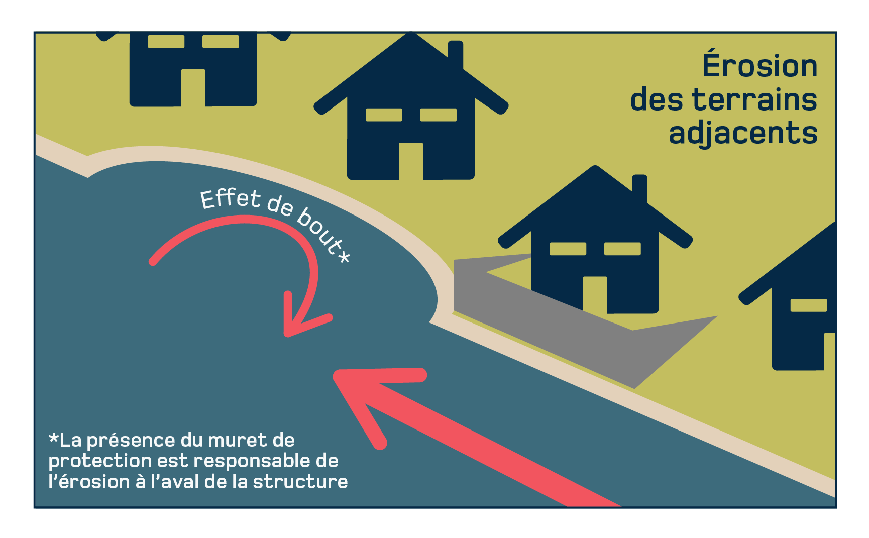
Some kinds of coastal development can accelerate erosion at the ends of structures.

This phenomenon, known as flanking erosion, refers to the disruption of longshore drift caused by a rigid protective structure, such as a wall, preventing wave energy from dissipating. This energy concentrates and causes erosion of the land adjacent to the structure.
The influence of climate-related factors on coastal erosion and submergence
Observations indicate that climate change is already contributing to an increase in the frequency and intensity of coastal erosion and submergence in Quebec.
There are several climate-related phenomena that explain this trend, including reduced ice cover, rising sea levels, changes in the frequency and intensity of storm surges, shifting seasons and increasing freeze-thaw events.
A decrease in ice cover
In Quebec, shrinking ice cover on the St. Lawrence River is one of the main factors exacerbating coastal erosion and submergence. Since the 1990s, there has been a marked decrease in ice cover, which plays a crucial role as a physical barrier against erosion caused by waves in the winter.
In 2024, a record was set: less than 10% of the surface of the St. Lawrence was covered by ice, the lowest level in 50 years. This trend, which seems to be continuing, exposes the coastline to more storm surges.
Relative sea level rise
Quebec is no exception to the global rise in sea levels, estimated at 3.2 mm per year between 1993 and 2015.
The sea level is rising faster than the global average in the southern Gulf of St. Lawrence. In the Magdalen Islands, sea level rose by an average of 4.3 mm per year between 1964 and 2014, which can be explained by the region’s glacial history.
In the Gulf of St. Lawrence and St. Lawrence Estuary regions as a whole, the rising sea level is accentuating gradual coastal erosion and increasing the intensity of coastal flooding during storm surges.
More devastating storm surges without ice cover
Although it’s difficult to establish trends in the intensity and frequency of storms in Quebec due to the variance from one decade to the next, the combined effect of storm surges and shrinking ice cover worsens erosion episodes and coastal flooding.
The storm on December 16, 2016, washed away a stretch of Route 132, isolating the Gaspé village of La Martre for nearly three days. This event, which took place during a winter when ice cover was abnormally low, bears witness to the severity the impacts of storm surges on coastlines with no ice cover.